Wetter and colder than average - very unsettled 18-20th with several named storms and then followed by the first frosts of the season
On the whole September was a fairly quiet, but disappointing month, both notably wetter and colder than average, but which in the second half of the month brought some interesting weather.
With a particularly disturbed period of weather 18-19th that had two named storms, preceded by an ex hurricane, which collectively brought a day of gales and one particularly wet day, which became the eighth wettest in my records and which was then followed by a cold spell with some ground frosts, September certainly heralded the start of autumn.
The month might appear to have been uneventful with there just having been one 'day of ...' (a gale on the 19th), but that wasn't really the case. Storms 'Helene, Ali and Bronagh' came in quick succession and then there was the first air and ground frosts of the season, which by recent standards are quite early and additionally on the 24th Maulds Meaburn was the coldest location in NW England, so there was at least something to write about.
MSLP of 1018.2 Mb was +4.1 Mb above the local average for September which considering the cool and wet aspect to the month with sizeable unsettled spells, is quite a surprisingly large departure.
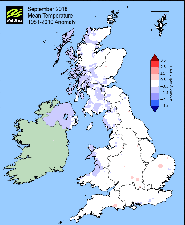
Overall a mean minimum of 7.71°c and a mean maximum of 15.65°c saw the temperature 1.4°c below the 1981-2010 average. It was the coldest since 2015 and of the ten now recorded, two have been colder and seven warmer. The highest maximum temperature recorded was 20.0°c (2nd), the lowest minimum -0.6°c (24th).
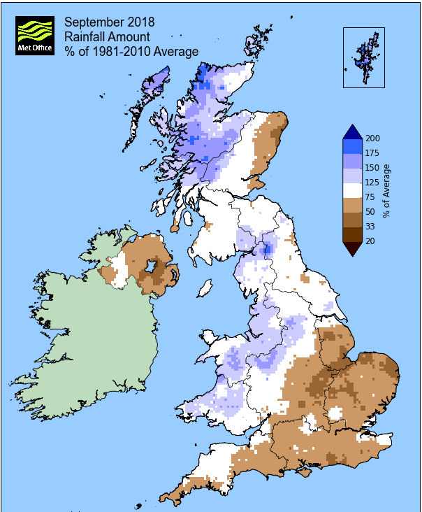
Rainfall of 125.7 mm (Crosby Ravensworth School 134.8 mm - Castlehowe Scar 157.1 mm - Reagill 96.8 mm) was 150.7% of average for 2007-17 and made it the driest September since 2016. Of the twelve now recorded, nine have been drier and two have been wetter - although with four years being within 3.2 mm of each other, 2018 could have been anywhere between from the second to the fifth wettest.
At the Met' Office site at Newton Rigg, rainfall of 94.6 mm (124%) was the driest since 2016 and in a series back to 1900 (data missing in 2 years), September has been drier in 81 years and wetter in 35 years.
A mean temperature of 11.78°c is the warmest since 2016 and in a series back to 1951, September has been warmer on 42 occasions, colder 21 times and with 4 years having the same mean temperature.
Locally, rainfall percentages were above average, typically around 115-125%, but with Brothers Water at 94.3% being a notable exception.
Figures from the Environment Agency’s rainfall sites were, (figure in brackets being the monthly average for 1961-90) ‘Data kindly provided by the Hydrometry and Telemetry team of the Environment Agency (Penrith)’:
Kirkby Thore ** mm (69.7 mm)
Haresceugh Castle (Kirkoswald) 102.42 mm (88.1 mm)
Brothers Water 229.15 mm (243 mm) and
Orton (Shallowford) ** mm (127.1 mm [average for 1967-2017])
362.6 mm at Seathwaite Farm (Borrowdale - 270 mm [average for 1981-2010]).
** not yet available
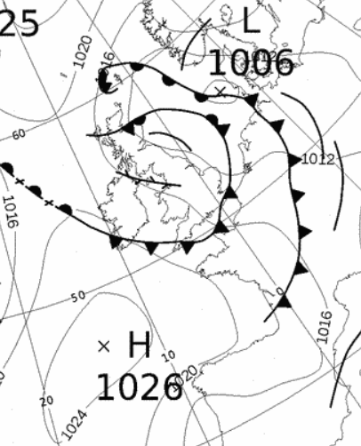
1st - 7th It was something of a battle between areas of high pressure (HP) and low pressure (LP) at the start of the month and consequently the weather was somewhat mixed with no particular pattern becoming established.
HP was centred in the North Sea on the 1st, moving towards Denmark, but a frontal system associated to LP near Iceland was never too far away from the UK and which did bring a little rain at times. Although the frontal system made slow progress against the HP, rainfall totals were slight on the 1st and 2nd. The days were generally overcast, in particular on the 3rd when the front did finally move across the UK, bringing a grey, drab day and 6.7 mm of rain.
However, the 1st and 2nd had been mild, the 2nd more so at 20°c, but the cold front on the 3rd saw the temperature fall to 15.7°c.
Then it was the turn of HP in the Atlantic to ridge in over the UK and this did result in more of the way of sunshine on the 4-5th despite more fronts encroaching on the UK from the north. Towards the end of the period the HP was barely exercising any control as it became squeezed south by the fronts from the north. However, behind a cold front that had moved south and created a nominal N'ly flow, the HP ridged back in overnight and the result was the first ground frost of the season (-1.2°c), relatively early by recent standards.
8th - 11th The next few days were generally unsettled with a succession of LP systems bringing spells of rain and temperatures falling back to the seasonal norm'.
The wind backed to a SSW'ly and 6.1 mm was recorded on the 8th, but with the main belt of rain (20.2 mm) sweeping through from the afternoon of the 10th and through the night into the 11th. Whilst breezy, the 11th was then a gradually improving picture behind the cold front as it cleared east.
12th - 15th HP in the Atlantic again tried to ridge over the UK, but never really took control, being held just to the south with a strong SSW'ly flow over its northern edge.
The 12th got to see some sunny intervals with the 13th cloudier ahead of an occluded front associated to LP moving east to the north of the UK. This front brought the occasional shower and a little rain overnight into the 14th and then with HP building over Normandy, it had the effect of holding the front up over Cumbria and this brought spells of rain in the evening of the 14th and again overnight into the 15th.
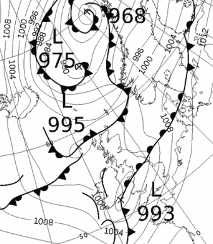
16th - 21st Through the period a succession of LP systems brought stormy and very unsettled conditions to the UK - the first of which was ex-hurricane 'Helene' (18th), quickly followed by 'Storm Ali' (19th), the first named UK storm of the season and then 'Storm Bronagh' (20th-21st).
The 16th saw a frontal system overnight bring wet conditions, but which was followed by a reasonable day. The 17th was a case of waiting for Helene to arrive and in an a mild S'ly flow there were a number of showers and spells of light rain. Helene arrived overnight into the 18th, but after rain from overnight had cleared in the late morning it was only a blustery day and nothing notable.
The arrival of 'Storm Ali' during the morning of the 19th was much more interesting! The day was windy to start and there followed a spell of rain for a hour from 1100 hrs, but after this had died away the wind really picked up. There were numerous gusts over 60 Mph, peaking at 63 Mph (1230 hrs) and many more over 50 Mph, but the wind was at its highest sustained strength between 1310-1345 hrs and just peaked at Gale Force.
With trees still fully laden with leaves, several were blow over and/or had major branches snapped off, but the winds slowly abated and the night became that bit calmer.
'Helene' and 'Ali' bringing stormy conditions.
It was then the turn of 'Bronagh'.
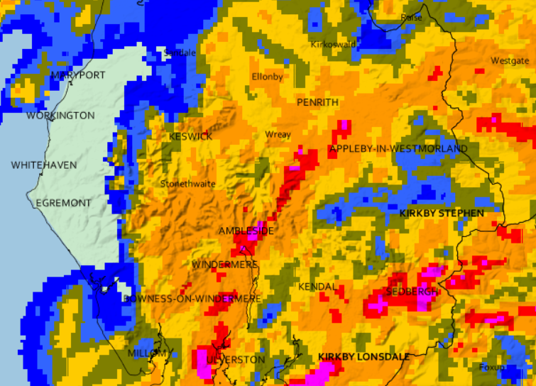
Bronagh was a 'rainfall event' and with 50.8 mm became the 8th wettest day in my records - somewhat bizarrely two of the top eight wettest days recorded here have fallen in September!
Ahead of Bronagh arriving there were a few sunny intervals before the cloud thickened with rain arriving from 2 p.m. It became heavier as the day progressed, but peaked between 9-11 p.m. becoming heavy - the rainfall radar map below gives a good indication of this.
Cumbria sat at the more northern tip of Bronagh and hence did not experience the strong winds on its southern flank and the following day (21st) saw the winds veer NW'ly and it was all quite fresh with frequent showers.
'The rainfall radar shows a heavy belt of rain in a line from Ambleside to Appleby.
22nd - 25th Under the influence of HP in the Atlantic that became established over the UK, the weather now settled down to something much quieter. However, with the UK being on the eastern edge of that HP we were subject to a nominal NW'ly flow and with the clearer skies we experienced the first and relatively early, air frost of the season - it was certainly feeling much cooler and fresher!
The HP slowly built during the 22nd/23rd and whilst there were decent amounts of sun, the NW'ly flow saw the temperatures struggle in the range of 12-13°c. Whilst there had been ground frost on the 23rd, with the HP now more dominant over the UK, the 24th started with that air frost, -0.6°c (30.9°f) - this actually saw Maulds Meaburn being the coldest location in the NW of England with all other sites remaining just above freezing!
The HP slipped east into Europe during the period and by the 25th was beginning to draw in a SSW'ly flow with fronts approaching the UK from the Atlantic.
26th - 27th With the HP having moved east into Europe the UK now drew up a much milder SSW'ly flow.
After a murky start to the 26th the day slowly brightened and in a little afternoon sunshine the temperature responded, rising to 19.8°c and it remained mild overnight into the 27th with a minimum of 13.2°c.
28th - 30th The month finished with the HP in the Atlantic re-asserting itself, giving a couple of decent sunny days, if a little on the chilly side.
After a cold start with a ground frost, the 28th was a glorious sunny day, but it was a case of 'warm in the sun, cool in the shade'. The 29th saw the HP being squeezed out as a cold front north of Scotland moved south, but it was still another sunny, but cool day.
With a maximum of just 11.7°c the 30th was the month's coldest day and it felt it with a mix of drizzle, light showers, sunny intervals and breezy conditions - autumn was here and had settled in.
Rainfall totalled 125.7 mm for the month, with rain recorded on 17 days of which 14 were 'Wet days' (1.0mm +).
The Mean Temperature for the month was 11.68°c -- The Mean Max' was 15.65°c -- The Mean Min' 7.71°c.
We had 1 Air Frost in the month (year 48) -- Grass frosts totalled 5 (year 80).
The 1 foot soil temp ranged from a low of 11.7°c on the 25th to a high of 16.1°c on the 3rd -- with a monthly mean of 13.9°c
The 1 meter soil temp ranged from a low of 12.9°c on the 30th to a high of 14.9°c on the 5th -- with a monthly mean of 14.0°c
COMPARISONS:-
* September 2018 rainfall was 150.7% of the September average for 2008 - 2017
* September 2018 was 0.88°c colder than the September average for 2009 - 2017 and 1.4°c colder than the local long term average 1981-2010
* This makes the Jan' to Sept' period of 2018 0.18°c warmer than the average for 2009-17 and with 86.9% of average rainfall for 2008-17
JANUARY 2010
FEBRUARY 2010
MARCH 2010
APRIL 2010
MAY 2010
JUNE 2010
JULY 2010
AUGUST 2010
SEPTEMBER 2010
OCTOBER 2010
NOVEMBER 2010
DECEMBER 2010
JANUARY 2011
FEBRUARY 2011
MARCH 2011
APRIL 2011
MAY 2011
JUNE 2011
JULY 2011
AUGUST 2011
SEPTEMBER 2011
OCTOBER 2011
NOVEMBER 2011
DECEMBER 2011
JANUARY 2012
FEBRUARY 2012
MARCH 2012
APRIL 2012
MAY 2012
JUNE 2012
JULY 2012
AUGUST 2012
SEPTEMBER 2012
OCTOBER 2012
NOVEMBER 2012
DECEMBER 2012
SUMMER 2012
REVIEW OF 2012
JANUARY 2013
FEBRUARY 2013
MARCH 2013
APRIL 2013
MAY 2013
JUNE 2013
JULY 2013
AUGUST 2013
SEPTEMBER 2013
OCTOBER 2013
NOVEMBER 2013
DECEMBER 2013
REVIEW OF 2013
JANUARY 2014
FEBRUARY 2014
MARCH 2014
APRIL 2014
MAY 2014
JUNE 2014
JULY 2014
AUGUST 2014
SEPTEMBER 2014
OCTOBER 2014
NOVEMBER 2014
DECEMBER 2014
WINTER 2014
REVIEW OF 2014
JANUARY 2015
FEBRUARY 2015
MARCH 2015
APRIL 2015
MAY 2015
JUNE 2015
JULY 2015
AUGUST 2015
SEPTEMBER 2015
OCTOBER 2015
NOVEMBER 2015
DECEMBER 2015
REVIEW OF 2015
JANUARY 2016
FEBRUARY 2016
MARCH 2016
APRIL 2016
MAY 2016
JUNE 2016
JULY 2016
AUGUST 2016
SEPTEMBER 2016
OCTOBER 2016
NOVEMBER 2016
DECEMBER 2016
REVIEW OF 2016
JANUARY 2017
FEBRUARY 2017
MARCH 2017
APRIL 2017
MAY 2017
JUNE 2017
JULY 2017
AUGUST 2017
SEPTEMBER 2017
OCTOBER 2017
NOVEMBER 2017
DECEMBER 2017
REVIEW OF 2017
JANUARY 2018
FEBRUARY 2018
MARCH 2018
APRIL 2018
MAY 2018
JUNE 2018
JULY 2018
AUGUST 2018
OTHER ARTICLES
The Oldest Inhabitant
An Inch Of Scotch Mist
But it's meant to be Summer (Summer 2017)
© Darren Rogers 2010-18
Want to comment on this site? email